James Mishler’s Color Maps of TSR’s Known World
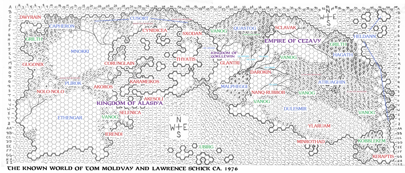
On Saturday Lawrence Schick posted The “Known World” D&D Setting: A Secret History here at Black Gate, a look behind the scenes at the early version of TSR’s Known World, one of the earliest published settings for Dungeons and Dragons. Yesterday Lawrence pointed me to James Mishler’s blog, Adventures in Gaming V2, where he said Mishler had “taken the maps from our article and transformed them into labeled, full-color wonders.” That’s an example of Mishler’s re-worked maps above (click for legible version). Here’s what Mishler said on his blog, in part:
Lawrence Schick, one of the early designers of Dungeons & Dragons at TSR, has revealed some interesting maps that detail the Original Known World that he and Tom Moldvay used in their Kent, Ohio Dungeons & Dragons campaign. If the “Known World” sounds familiar, it is because it is the world that was used in the 1981 edition of Basic/Expert Dungeons & Dragons, revealed in the module X1: The Isle of Dread and detailed further in the Expert Set book… He has posted several maps and note sheets with this article on the Black Gate website…
It is not exactly the same world, but instead is obviously the progenitor of the Known World that eventually evolved into Mystara. When Tom Moldvay, David Cook, and the rest of the development team for B/X needed to use a world, they went back and borrowed from Moldvay and Schick’s Original Known World. Many of the names and ideas survived; you can also see much of the TSR Known World geography owes its design to the Original Known World’s eastern half.
So as usual, when I get excited about mapping stuff, especially when it comes to one of my favorite campaign settings, I kind of took the maps presented and ran with them…
James took Moldvay and Schick’s hand-made Known World maps and knit them together with annotations of location names to create the image above. He also created Hexographer versions of the Western and Eastern Known World, and a jumbo map of both stitched together. See the impressive results on his blog.
More fascinating stuff! Interesting to see how things evolved over the years.
[…] in the piece continues to be high and last week James Mishler, who painstakingly produced color versions of Lawrence’s original hand-drawn maps, conducted a detailed Q&A with Lawrence on his […]